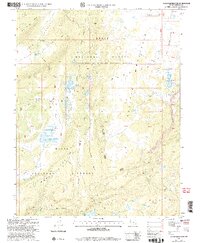
2002 Map of Jacobs Reservoir
USGS Topo · Published 2005About this map
The Aquarius Plateau dominates this landscape, showing a high-altitude wilderness defined by its complex hydrology and dramatic relief. Boulder Mountain rises above a series of distinct basins and draws, including Dark Valley and Broken Draw. The map reveals a high concentration of subalpine water bodies such as Purple Lake, Bakeskillet Lake, and the larger Jacobs Reservoir, suggesting a terrain shaped by glacial action and volcanic history. Administratively, the area is divided between the Loa - Teasdale Ranger District and the Escalante Ranger District within the Dixie National Forest. A network of high-country routes, most notably the Great Western Trail and the Burr Trail, provides evidence of long-standing paths through the backcountry, while family-named landmarks like Mc Gath Lake offer clues for local genealogists and researchers.
Find a feature on this map
54 named features on this map. Tap any name to fly to it.
Don’t see what you’re looking for? This feature index may not catch every label — zoom into the map to look around manually.
Map Details
Editions of this 2002 Jacobs Reservoir Map
This is the sole edition of this map. No revisions or reprints were ever made.
Other maps of this area

1885 · Fish Lake
USGS Topo · 1:250,000

1886 · Escalante
USGS Topo · 1:250,000

1896 · Fish Lake
USGS Topo · 1:250,000

1952 · Notom 3 SW
USGS Topo · 1:24,000

1952 · Notom 3 NW
USGS Topo · 1:24,000

1952 · Grover
USGS Topo · 1:62,500

1953 · Loa 4 NE
USGS Topo · 1:24,000

1956 · Escalante
USGS Topo · 1:250,000

1956 · Salina
USGS Topo · 1:250,000

1960 · Escalante
USGS Topo · 1:250,000