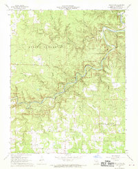
1968 Map of Jam Up Cave
USGS Topo · Published 1970About this map
Jacks Fork carves a winding path through the Ozark landscape of Shannon County, documented here shortly after the establishment of the Ozark National Scenic Riverways. The river is flanked by prominent geological formations like Chalk Bluff and Red Bluff, while the subterranean character of the region is evident in the numerous named caverns such as Jam Up Cave, Meeting House Cave, and Peter Renfro Cave. The map reveals a remote, karst-influenced terrain where water disappears into features like Spring Hollow and re-emerges at Rymer Spring or Bunker Hill Spring. Local history is anchored by the Turkey Oak Cem and Bures Ch in the southern portion of the quadrangle, reflecting the sparse but established upland settlements within the Birch Tree and Montier districts during the late 1960s.
Find a feature on this map
43 named features on this map. Tap any name to fly to it.
Don’t see what you’re looking for? This feature index may not catch every label — zoom into the map to look around manually.
Map Details
Editions of this 1968 Jam Up Cave Map
4 editions found
Other maps of this area

1915 · Eminence
USGS Topo · 1:62,500

1917 · Eminence
USGS Topo · 1:62,500

1931 · Bandyville
USGS Topo · 1:48,000

1944 · Birch Tree
USGS Topo · 1:62,500

1945 · Montier
USGS Topo · 1:62,500

1946 · Summersville
USGS Topo · 1:62,500

1948 · Montier
USGS Topo · 1:62,500

1948 · Birch Tree
USGS Topo · 1:62,500

1948 · Summersville
USGS Topo · 1:62,500

1949 · Rolla
USGS Topo · 1:250,000