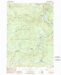
1986 Map of Jamaica
USGS Topo · Published 1987About this map
Jamaica and the cluster of Wardsboro villages define this pocket of the Green Mountain National Forest during the mid-1980s. The landscape is shaped by the steep relief of College Hill and Sage Hill, with the West River carving through the eastern edge. This survey documents a community tied to the land and water, featuring the Ball Mountain Reservoir and a network of mountain brooks like Kidder Bk and Sage Hill Brook. Local life is anchored by several Cem locations and small settlements such as Wardsboro Center and West Wardsboro. The map illustrates the balance between managed wilderness and rural residency, showing the boundaries of Ball Mtn State Park alongside smaller features like the Gravel Pit near West Jamaica and the quiet waters of Forester Pond.
Find a feature on this map
38 named features on this map. Tap any name to fly to it.
Don’t see what you’re looking for? This feature index may not catch every label — zoom into the map to look around manually.
Map Details
Editions of this 1986 Jamaica Map
This is the sole edition of this map. No revisions or reprints were ever made.
Other maps of this area

1889 · Wilmington
USGS Topo · 1:62,500

1891 · Wilmington
USGS Topo · 1:62,500

1891 · Brattleboro
USGS Topo · 1:62,500

1893 · Brattleboro
USGS Topo · 1:62,500

1894 · Londonderry
USGS Topo · 1:62,500

1899 · Londonderry
USGS Topo · 1:62,500

1899 · Wilmington
USGS Topo · 1:62,500

1930 · Saxtons River
USGS Topo · 1:48,000

1932 · Brattleboro
USGS Topo · 1:48,000

1933 · Saxtons River
USGS Topo · 1:62,500