
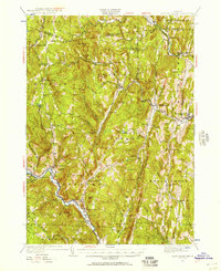
1930 Map of Saxtons River
USGS Topo · Published 1930About this map
The West River and Saxtons River valleys define the settlement patterns of this Windham County landscape during the late 1920s. Small villages and crossroads hamlets like Grafton and Townshend serve as central nodes for a network of rural school districts, including the uniquely named Round Sch (Dist No 1) and Brookside Sch. The industrial and transport pulse of the era is evident along the Williams River, where the Rutland RR connects Bartonsville and Brockway Mills to the wider region. Many of these upland communities, such as Howeville and South Windham, are documented here just as early aerial photography, conducted by the U.S. Army Air Corps, began to modernize topographical surveying. The map reveals a high density of small-scale educational infrastructure, with labels for the Valley Sch, Walker Sch, and Pettee Hill Sch reflecting a decentralized mountain society before the mid-century consolidation of rural schools.
Find a feature on this map
51 named features on this map. Tap any name to fly to it.
Don’t see what you’re looking for? This feature index may not catch every label — zoom into the map to look around manually.
Map Details
Editions of this 1930 Saxtons River Map
2 editions found
Other maps of this area

1889 · Wilmington
USGS Topo · 1:62,500

1891 · Wilmington
USGS Topo · 1:62,500

1891 · Brattleboro
USGS Topo · 1:62,500

1893 · Wallingford
USGS Topo · 1:62,500

1893 · Brattleboro
USGS Topo · 1:62,500

1894 · Londonderry
USGS Topo · 1:62,500

1898 · Keene
USGS Topo · 1:62,500

1899 · Londonderry
USGS Topo · 1:62,500

1899 · Wilmington
USGS Topo · 1:62,500

1926 · Claremont
USGS Topo · 1:62,500