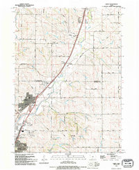
1994 Map of James
USGS Topo · Published 1995About this map
The Floyd River valley serves as a primary corridor through this portion of Woodbury and Plymouth Counties, where the Chicago and North Western railroad tracks parallel the water. The settlement of James sits north of the Sioux City corporate boundary, while the northern neighborhoods of the city itself, including Leeds and Springdale, show the residential and industrial interface of the mid-1990s. Landmarks such as the St Michaels Sch and Garfin Park anchor these established communities.
Find a feature on this map
40 named features on this map. Tap any name to fly to it.
Don’t see what you’re looking for? This feature index may not catch every label — zoom into the map to look around manually.
Map Details
Editions of this 1994 James Map
This is the sole edition of this map. No revisions or reprints were ever made.
Other maps of this area

1955 · Sioux City
USGS Topo · 1:250,000

1958 · Sioux City
USGS Topo · 1:250,000

1959 · Sioux City
USGS Topo · 1:250,000

1962 · Union Center
USGS Topo · 1:62,500

1963 · Sioux City South
USGS Topo · 1:24,000

1963 · Sioux City North
USGS Topo · 1:24,000

1964 · Sergeant Bluff
USGS Topo · 1:24,000

1964 · James
USGS Topo · 1:24,000

1964 · Hinton
USGS Topo · 1:24,000

1964 · Lawton
USGS Topo · 1:24,000