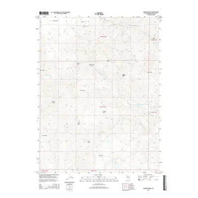
2015 Map of Jamison Ridge
USGS Topo · Published 2015About this map
Middle Fork Eel River snakes through the center of this Mendocino County landscape, carving deep canyons between high ridges like Jamison Ridge and Jarbow Ridge. This 2015 edition captures a transition from the level floor of Round Valley in the northwest corner toward the remote interior mountains. To the south, the terrain descends into Paradise Valley and Eden Valley, the latter featuring Toney Cr. Local history is anchored by Pioneer Cemetery near Hinman Ln, while the presence of Marks Place suggests a legacy of homesteading or early ranching in this isolated terrain. The map is heavily marked by numerous natural springs, such as Redwine Spring, Iron Spring, and Jarbow Spring, which historically supported life and livestock along the steep divides of Pedro Ridge and the Salt Creek Divide.
Find a feature on this map
42 named features on this map. Tap any name to fly to it.
Don’t see what you’re looking for? This feature index may not catch every label — zoom into the map to look around manually.
Map Details
Editions of this 2015 Jamison Ridge Map
This is the sole edition of this map. No revisions or reprints were ever made.
Other maps of this area

1920 · Covelo
USGS Topo · 1:62,500

1926 · Covelo
USGS Topo · 1:62,500

1929 · Eden Valley
USGS Topo · 1:62,500

1951 · Laytonville
USGS Topo · 1:62,500

1952 · Spyrock
USGS Topo · 1:62,500

1952 · Eden Valley
USGS Topo · 1:62,500

1952 · Covelo
USGS Topo · 1:62,500

1957 · Ukiah
USGS Topo · 1:250,000

1960 · Ukiah
USGS Topo · 1:250,000
1966 · Sanhedrin Mtn
USGS Topo · 1:24,000