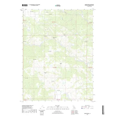
2018 Map of Jamison Ridge
USGS Topo · Published 2018About this map
Foster / Old Pioneer Cem sits at the northern edge of this territory, marking the historical roots of the area's early settlers near the base of Round Valley. The landscape is defined by the significant corridor of the Middle Fork Eel River, which carves through the center of the terrain, flanked by prominent elevations like Jarbow Ridge and Jamison Ridge. These high points separate several distinct basins, including Paradise Valley and the expansive Eden Valley to the south.
Find a feature on this map
47 named features on this map. Tap any name to fly to it.
Don’t see what you’re looking for? This feature index may not catch every label — zoom into the map to look around manually.
Map Details
Editions of this 2018 Jamison Ridge Map
This is the sole edition of this map. No revisions or reprints were ever made.
Other maps of this area

1920 · Covelo
USGS Topo · 1:62,500

1926 · Covelo
USGS Topo · 1:62,500

1929 · Eden Valley
USGS Topo · 1:62,500

1951 · Laytonville
USGS Topo · 1:62,500

1952 · Spyrock
USGS Topo · 1:62,500

1952 · Eden Valley
USGS Topo · 1:62,500

1952 · Covelo
USGS Topo · 1:62,500

1957 · Ukiah
USGS Topo · 1:250,000

1960 · Ukiah
USGS Topo · 1:250,000
1966 · Sanhedrin Mtn
USGS Topo · 1:24,000