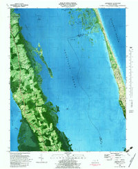
1982 Map of Jarvisburg
USGS Topo · Published 1983About this map
Jarvisburg and the surrounding neck of land in Currituck County are documented in this orthophotomap, which combines traditional topographic data with aerial photography. This perspective highlights the concentrated agricultural fields and residential corridors along the mainland, contrasting sharply with the extensive Tidal Flats and marshy fringes of the Currituck Sound. Along the narrow barrier beach to the east, the settlement of Caffey and a Landing Strip stand between the sound and the Atlantic Ocean.
Find a feature on this map
41 named features on this map. Tap any name to fly to it.
Don’t see what you’re looking for? This feature index may not catch every label — zoom into the map to look around manually.
Map Details
Editions of this 1982 Jarvisburg Map
This is the sole edition of this map. No revisions or reprints were ever made.
Other maps of this area

1940 · Barco
USGS Topo · 1:62,500

1940 · Kitty Hawk
USGS Topo · 1:62,500

1940 · Powells Point
USGS Topo · 1:62,500

1946 · Eastville
USGS Topo · 1:250,000

1946 · Currituck Sound
USGS Topo · 1:250,000

1961 · Eastville
USGS Topo · 1:250,000

1966 · Eastville
USGS Topo · 1:250,000
1982 · Kitty Hawk
USGS Topo · 1:24,000
1982 · Point Harbor
USGS Topo · 1:24,000
1982 · Martin Point
USGS Topo · 1:24,000