
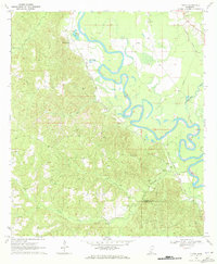
1970 Map of Jayess
USGS Topo · Published 1972About this map
Jayess serves as a focal point in this 1970 landscape, where the rural character of Walthall and Lawrence Counties is defined by a dense network of country churches and small family-named cemeteries. The terrain is marked by the winding courses of Topisaw Cr and Magees Creek, while an old Railroad Grade cutting through the northern section suggests a legacy of earlier timber or agricultural transport. Infrastructure of the era is evident in the McComb Compressor Station and several Pipeline corridors, alongside industrial activity represented by scattered Gravel Pits. Local community life is grounded in long-standing institutions such as New Hope Ch, Bethel Ch, and New Bethel Sch, providing a detailed look at the social geography of south Mississippi before significant modern development altered these traditional settlement patterns.
Find a feature on this map
30 named features on this map. Tap any name to fly to it.
Don’t see what you’re looking for? This feature index may not catch every label — zoom into the map to look around manually.
Map Details
Editions of this 1970 Jayess Map
This is the sole edition of this map. No revisions or reprints were ever made.
Other maps of this area

1953 · Natchez
USGS Topo · 1:250,000

1956 · Natchez
USGS Topo · 1:250,000

1959 · Natchez
USGS Topo · 1:250,000

1970 · Kokomo
USGS Topo · 1:24,000

1970 · Mesa
USGS Topo · 1:24,000

1970 · Topeka
USGS Topo · 1:24,000

1970 · Darbun
USGS Topo · 1:24,000
1970 · Tilton
USGS Topo · 1:24,000

1972 · Ruth
USGS Topo · 1:24,000

1972 · Pricedale
USGS Topo · 1:24,000