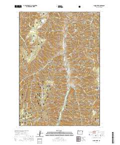
2020 Map of Jaynes Ridge
USGS Topo · Published 2020About this map
The Imnaha Wild and Scenic River carves a deep central artery through the eastern reaches of the Wallowa National Forest, defining a landscape of high ridges and steep canyons. For genealogists and local historians, the Park Cem sits along the river's western bank, a solitary marker of past residence in this secluded terrain. The geography is dominated by complex systems of gulches and ridges, including Jaynes Ridge, Beeler Ridge, and Morgan Ridge, which served as critical navigation points for early travelers. Seasonal access is highlighted by the Hart Butte Snowmobile and Jaynes Ridge Snowmobile routes, while reliable water sources like Himmelwright Spring and Tepee Spring illustrate the essential points of survival and livestock management in the high country.
Find a feature on this map
51 named features on this map. Tap any name to fly to it.
Don’t see what you’re looking for? This feature index may not catch every label — zoom into the map to look around manually.
Map Details
Editions of this 2020 Jaynes Ridge Map
This is the sole edition of this map. No revisions or reprints were ever made.
Other maps of this area

1920 · Seven Devils Mining District
USGS Topo · 1:48,000

1922 · He Devil
USGS Topo · 1:48,000

1954 · Harl Butte
USGS Topo · 1:62,500

1955 · Grangeville
USGS Topo · 1:250,000

1957 · He Devil
USGS Topo · 1:62,500

1957 · Cuprum
USGS Topo · 1:62,500

1957 · Homestead
USGS Topo · 1:62,500

1959 · Grangeville
USGS Topo · 1:250,000

1987 · Riggins
USGS Topo · 1:100,000
1990 · Puderbaugh Ridge
USGS Topo · 1:24,000