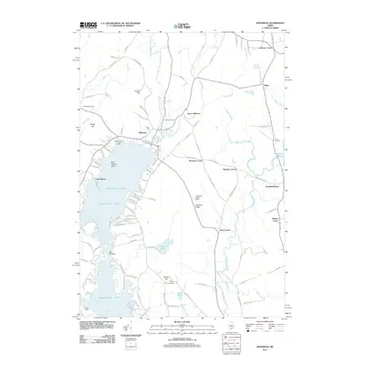
2011 Map of Jefferson
USGS Topo · Published 2011About this map
Damariscotta Lake defines the western landscape of this Maine quadrangle, where the waters of the Dyer River and Davis Stream converge. The settlement of Jefferson sits at the northern tip of the lake, serving as a central point for a network of rural roads and historical homesteads. The map illustrates a community anchored by traditional land use, from the Brown Homestead in the south to outlying crossroads like Stickney Corner and Globe in the north. Numerous cemeteries, including Shepherd Cemetery and Fairview Cemetery, are scattered across the terrain, offering significant points of interest for genealogists tracing local families. The presence of recreational landmarks such as Camp Wavus and Camp Kieve along the shoreline highlights the enduring importance of the lake to the region's seasonal identity, while the eastern reaches are drained by the Medomak River near North Waldoboro.
Find a feature on this map
109 named features on this map. Tap any name to fly to it.
Don’t see what you’re looking for? This feature index may not catch every label — zoom into the map to look around manually.
Map Details
Editions of this 2011 Jefferson Map
This is the sole edition of this map. No revisions or reprints were ever made.
Other maps of this area

1893 · Vassalboro
USGS Topo · 1:62,500

1893 · Wiscasset
USGS Topo · 1:62,500

1898 · Vassalboro
USGS Topo · 1:62,500

1913 · Waldoboro
USGS Topo · 1:48,000

1915 · Waldoboro
USGS Topo · 1:62,500

1916 · Liberty
USGS Topo · 1:62,500

1941 · Waldoboro
USGS Topo · 1:62,500

1941 · Vassalboro
USGS Topo · 1:62,500

1942 · Liberty
USGS Topo · 1:62,500

1943 · Vassalboro
USGS Topo · 1:62,500