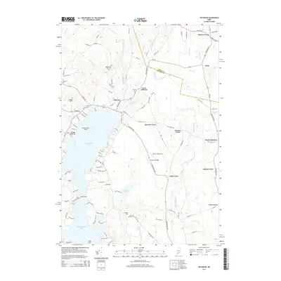
2014 Map of Jefferson
USGS Topo · Published 2014About this map
Jefferson sits at the northern reaches of Damariscotta Lake, serving as a central hub for the surrounding Lincoln County countryside. This landscape is defined by its complex network of waterways, including the Dyer River and Davis Stream, which feed into the lake. The map reveals a pattern of rural settlement concentrated at named intersections, such as Kennedy Corner, Flanders Corner, and Stickney Corner. These crossroads, along with scattered burial grounds like Fairview Cem and Shepherd Cem, provide essential anchor points for local genealogical research. In the southwest, the wooded shores of the lake host Camp Wavus near Bird Feather Island. To the east, the terrain transitions toward the Medomak River valley, where the small community of North Waldoboro and the high ground of Robinson Ridge overlook the surrounding timberlands and small ponds like Cooks Pond and Tobias Pond.
Find a feature on this map
116 named features on this map. Tap any name to fly to it.
Don’t see what you’re looking for? This feature index may not catch every label — zoom into the map to look around manually.
Map Details
Editions of this 2014 Jefferson Map
This is the sole edition of this map. No revisions or reprints were ever made.
Other maps of this area

1893 · Vassalboro
USGS Topo · 1:62,500

1893 · Wiscasset
USGS Topo · 1:62,500

1898 · Vassalboro
USGS Topo · 1:62,500

1913 · Waldoboro
USGS Topo · 1:48,000

1915 · Waldoboro
USGS Topo · 1:62,500

1916 · Liberty
USGS Topo · 1:62,500

1941 · Waldoboro
USGS Topo · 1:62,500

1941 · Vassalboro
USGS Topo · 1:62,500

1942 · Liberty
USGS Topo · 1:62,500

1943 · Vassalboro
USGS Topo · 1:62,500