
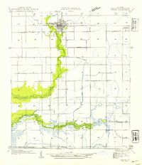
1946 Map of Jennings
USGS Topo · Published 1946About this map
The Jennings street grid centers this 1946 advance sheet, revealing a landscape defined by the intersection of the Southern Pacific railroad and early automotive routes like US Highway No 90. The map documents a transition from the structured town blocks of Jennings and the smaller settlement of Roanoke to the expansive agricultural and drainage networks of Jefferson Davis Parish. A complex system of waterways, including the Sturdivant Canal, Broadmore Ditch, and Keystone Ditch, highlights the region's reliance on water management for rice farming or other irrigation-heavy industries. Along the eastern edge, the Mermentau River and Bayou Nezpique form a natural boundary, their winding courses contrasting with the rigid section lines and state highways such as State Highway No 25 that partition the surrounding prairie.
Find a feature on this map
20 named features on this map. Tap any name to fly to it.
Don’t see what you’re looking for? This feature index may not catch every label — zoom into the map to look around manually.
Map Details
Editions of this 1946 Jennings Map
This is the sole edition of this map. No revisions or reprints were ever made.
Other maps of this area

1946 · Lake Arthur
USGS Topo · 1:31,680

1946 · Mermentau
USGS Topo · 1:31,680

1947 · Evangeline
USGS Topo · 1:31,680

1947 · Thornwell
USGS Topo · 1:31,680

1947 · Pine Island
USGS Topo · 1:31,680

1947 · Welsh
USGS Topo · 1:31,680

1947 · Hathaway
USGS Topo · 1:31,680

1949 · Gueydan
USGS Topo · 1:31,680

1952 · Lake Charles
USGS Topo · 1:250,000
1954 · Welsh
USGS Topo · 1:31,680