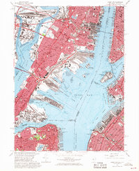
1967 Map of Jersey City
USGS Topo · Published 1969About this map
Jersey City and its surrounding waterfronts define this late 1960s study of the New York Harbor's industrial and residential heart. The landscape is dominated by the massive rail infrastructures of the Pennsylvania RR, Lehigh Valley RR, and C RR of N J, which converge at massive facilities like Greenville Yards and Meadows Yards. These transport arteries supported the dense neighborhoods of Communipaw, West Bergen, and Marion, while the iconic Statue of Liberty Nat Mon stands sentinel between the active shipping channels of Upper Bay and the Hudson River.
Find a feature on this map
104 named features on this map. Tap any name to fly to it.
Don’t see what you’re looking for? This feature index may not catch every label — zoom into the map to look around manually.
Map Details
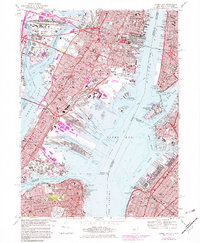
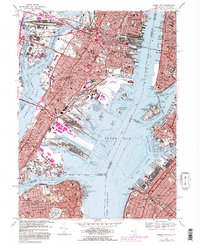
Editions of this 1967 Jersey City Map
3 editions found
Other maps of this area

1888 · Paterson
USGS Topo · 1:62,500

1889 · Brooklyn
USGS Topo · 1:62,500

1891 · Brooklyn
USGS Topo · 1:62,500

1891 · Harlem
USGS Topo · 1:62,500

1892 · Paterson
USGS Topo · 1:62,500

1897 · Harlem
USGS Topo · 1:62,500

1897 · Brooklyn
USGS Topo · 1:62,500

1898 · Harlem
USGS Topo · 1:62,500

1898 · Staten Island
USGS Topo · 1:62,500

1898 · Brooklyn
USGS Topo · 1:62,500