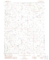
1988 Map of Jessies Twist
USGS Topo · Published 1988About this map
Gunnison Valley and the surrounding high desert terrain dominate this late 1980s landscape, where complex water management and industrial exploration define the land use. The map records a concentration of mining activity near Buckmaster and Buckmaster Draw, characterized by numerous Mine Shafts, Adits, and Prospect points. These features, alongside Borrow Pits and various Dumps, indicate a period of intense geological sampling and resource extraction in the San Rafael desert region.
Find a feature on this map
30 named features on this map. Tap any name to fly to it.
Don’t see what you’re looking for? This feature index may not catch every label — zoom into the map to look around manually.
Map Details
Editions of this 1988 Jessies Twist Map
This is the sole edition of this map. No revisions or reprints were ever made.
Other maps of this area

1885 · San Rafael
USGS Topo · 1:250,000

1886 · Price River
USGS Topo · 1:250,000

1896 · Price River
USGS Topo · 1:250,000

1953 · Tidwell 2 SW
USGS Topo · 1:24,000

1953 · Beckwith Peak SW
USGS Topo · 1:24,000

1953 · Tidwell 2 NW
USGS Topo · 1:24,000

1954 · Tidwell 1 SW
USGS Topo · 1:24,000

1954 · Tidwell 2 SE
USGS Topo · 1:24,000

1954 · Tidwell 2 NE
USGS Topo · 1:24,000

1954 · Tidwell 1 NW
USGS Topo · 1:24,000