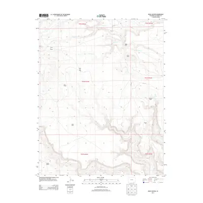
2013 Map of Jesus Canyon
USGS Topo · Published 2013About this map
Jesus Canyon and the surrounding high plains of Las Animas County define this arid landscape in southeastern Colorado. The map documents a rugged topography characterized by steep canyon walls and expansive tablelands, most notably the prominent Mesa de Maya and Jesus Mesa. This 2013 survey provides a clear look at the sparse ranching infrastructure and hydrological features that sustain life in this high-elevation environment. Water sources are critical but infrequent, appearing as seasonal drainages like Tomasa Cr and Owl Roost Cr, along with isolated points like Clay Spring. The presence of the Mayfield Ranch underscores the area's continued use for livestock grazing, while landmarks such as Cerro Negro and the Seven L Buttes serve as essential navigational markers across the complex terrain of Cobert Canyon and Flathead Canyon.
Find a feature on this map
24 named features on this map. Tap any name to fly to it.
Don’t see what you’re looking for? This feature index may not catch every label — zoom into the map to look around manually.
Map Details
Editions of this 2013 Jesus Canyon Map
This is the sole edition of this map. No revisions or reprints were ever made.
Other maps of this area

1891 · Mesa De Maya
USGS Topo · 1:125,000

1892 · Mt Carrizo
USGS Topo · 1:125,000

1893 · Mesa de Maya
USGS Topo · 1:125,000

1954 · Dalhart
USGS Topo · 1:250,000

1955 · La Junta
USGS Topo · 1:250,000

1958 · La Junta
USGS Topo · 1:250,000

1958 · Dalhart
USGS Topo · 1:250,000

1962 · Dalhart
USGS Topo · 1:250,000

1968 · La Junta
USGS Topo · 1:250,000

1972 · Travesser Park
USGS Topo · 1:24,000