1969 Map of Jetmore
USGS Topo · Published 1971About this map
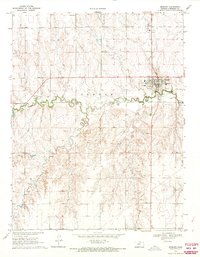
Jetmore serves as the focal point of this west-central Kansas landscape, situated at a bend in Buckner Creek where the A T & S F railroad terminates. The 1969 topography reveals a community structured around essential services, including a High Sch, Hospital, and municipal infrastructure like a Sewage Disposal plant. The local economy and land use are further marked by a Sandpit on the eastern edge of town and a Caliche Pit to the south, reflecting the extractive needs of the plains region.
Find a feature on this map
19 named features on this map. Tap any name to fly to it.
Don’t see what you’re looking for? This feature index may not catch every label — zoom into the map to look around manually.
Map Details
Editions of this 1969 Jetmore Map
This is the sole edition of this map. No revisions or reprints were ever made.
Other maps of this area

1892 · Ness
USGS Topo · 1:125,000

1892 · Dodge
USGS Topo · 1:125,000

1892 · Spearville
USGS Topo · 1:125,000

1894 · Spearville
USGS Topo · 1:125,000

1894 · Ness
USGS Topo · 1:125,000

1955 · Great Bend
USGS Topo · 1:250,000

1955 · Pratt
USGS Topo · 1:250,000

1955 · Dodge City
USGS Topo · 1:250,000

1955 · Scott City
USGS Topo · 1:250,000

1957 · Great Bend
USGS Topo · 1:250,000