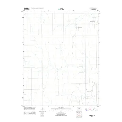
2012 Map of Jetmore NE
USGS Topo · Published 2012About this map
The sub-surface energy economy of Hodgeman County is clearly visible on this 2012 survey, which identifies several active production areas across the northern High Plains landscape. Operations such as the Wieland North Oil Field and the nearby Wieland West Oil Field occupy the higher ground between seasonal watercourses. The drainage patterns are defined by the winding paths of Sand Cr in the north and the extensive meanders of Dry Cr which cuts through the central portion of the quadrangle. Further south, the Hanston-Oppy Oil Field marks the industrial footprint of the region's petroleum extraction. This map illustrates the intersection of a rigid section-line road grid with the natural, erratic topography of the Kansas prairie, providing a detailed record of land use and resource management in the early 21st century.
Find a feature on this map
5 named features on this map. Tap any name to fly to it.
Don’t see what you’re looking for? This feature index may not catch every label — zoom into the map to look around manually.
Map Details
Editions of this 2012 Jetmore NE Map
This is the sole edition of this map. No revisions or reprints were ever made.
Other maps of this area

1892 · Ness
USGS Topo · 1:125,000

1894 · Ness
USGS Topo · 1:125,000

1955 · Great Bend
USGS Topo · 1:250,000

1957 · Great Bend
USGS Topo · 1:250,000

1958 · Great Bend
USGS Topo · 1:250,000

1969 · Jetmore
USGS Topo · 1:24,000

1970 · Jetmore SE
USGS Topo · 1:24,000
1970 · Hanston
USGS Topo · 1:24,000

1970 · Hanston NW
USGS Topo · 1:24,000

1970 · Jetmore NE
USGS Topo · 1:24,000