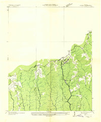
1935 Map of Jewell
USGS Topo · Published 1935About this map
Jewell Ridge PO and the community of Jewell anchor this mid-1930s survey along the mountainous border of Buchanan and Tazewell Counties. The landscape is defined by the high-elevation Sandy Ridge, where industrial development and transportation routes follow the narrow winding valleys. The Norfolk and Western railroad tracks run through the heart of the region, supporting local operations like Coaldan and Alfredton. An Electric Power Company Transmission Line traverses the ridges, signaling the modernization of this coal-producing area. Local life is centered around rural landmarks like Smith Sch, Maney Sch, and Stinson Sch, while the Bear Wallow Fire Tower stands as a sentinel over the high ground. The map details a complex network of hollows such as Wildcat Hollow and Chicken Coop Hollow that characterize the difficult terrain during this era of extraction and early highway development.
Find a feature on this map
40 named features on this map. Tap any name to fly to it.
Don’t see what you’re looking for? This feature index may not catch every label — zoom into the map to look around manually.
Map Details
Editions of this 1935 Jewell Map
This is the sole edition of this map. No revisions or reprints were ever made.
Other maps of this area

1891 · Tazewell
USGS Topo · 1:125,000

1895 · Tazewell
USGS Topo · 1:125,000

1897 · Tazewell
USGS Topo · 1:125,000

1910 · Iaeger
USGS Topo · 1:48,000

1912 · Pounding Mill
USGS Topo · 1:62,500

1912 · Iaeger
USGS Topo · 1:62,500

1912 · Welch
USGS Topo · 1:62,500

1914 · Iaeger
USGS Topo · 1:48,000

1915 · Richlands
USGS Topo · 1:48,000

1916 · Pounding Mill
USGS Topo · 1:62,500