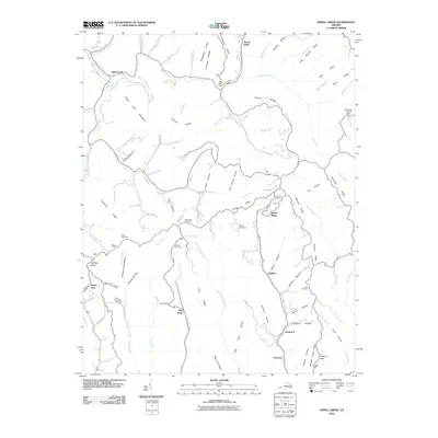
2010 Map of Jewell Ridge
USGS Topo · Published 2010About this map
Jewell Ridge and Whitewood anchor this survey of the high plateau and steep hollows of southwestern Virginia. The landscape is defined by its complex ridge-and-valley topography, where small communities like Coaldan, Glen Burke, and Seaboard are situated along the lower elevations of Middle Creek and Mudlick Creek. For genealogists and local researchers, the map identifies several family-named burial grounds, including the Sawyer Cemetery, Smith Cemetery, and Stevenson Cemetery, along with a larger Company Cemetery near the ridge summit. High points are dominated by long, parallel formations such as Smith Ridge and Stinson Ridge, while the Bearwallow Lookout Tower provides a strategic vantage point over the drainage basins of Dismal Creek and the Laurel Fork. The network of local roads like Tiller Rd and Wayne Rd connects these isolated settlements through gaps such as Shortt Gap and Low Gap.
Find a feature on this map
95 named features on this map. Tap any name to fly to it.
Don’t see what you’re looking for? This feature index may not catch every label — zoom into the map to look around manually.
Map Details
Editions of this 2010 Jewell Ridge Map
This is the sole edition of this map. No revisions or reprints were ever made.
Other maps of this area

1891 · Tazewell
USGS Topo · 1:125,000

1895 · Tazewell
USGS Topo · 1:125,000

1897 · Tazewell
USGS Topo · 1:125,000

1910 · Iaeger
USGS Topo · 1:48,000

1912 · Pounding Mill
USGS Topo · 1:62,500

1912 · Iaeger
USGS Topo · 1:62,500

1912 · Welch
USGS Topo · 1:62,500

1914 · Iaeger
USGS Topo · 1:48,000

1915 · Richlands
USGS Topo · 1:48,000

1916 · Pounding Mill
USGS Topo · 1:62,500