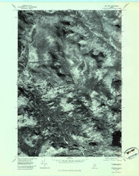
1977 Map of Jim Pond
USGS Topo · Published 1983About this map
Kibby Range dominates the rugged interior of this 1977 orthophotograph, a specialized document prepared by the Geological Survey to show the exact ground cover and drainage patterns of this Franklin County wilderness. Unlike traditional topographic maps, this imagery reveals the dense forest canopy and precise paths of the Dead River and its various tributaries. The confluence of the North Branch and the main river channel is clearly visible, as are the numerous smaller waterways like Gold Brook and Alder Stream that feed into the valley. At the eastern edge of the survey, Jim Pond provides a significant water feature amidst the high-elevation terrain. This orthophotoquad is an essential resource for those studying the hydrology of the Kibby Stream watershed and the undisturbed landscape of late-1970s Maine before modern development or forest management altered these specific slopes.
Find a feature on this map
9 named features on this map. Tap any name to fly to it.
Don’t see what you’re looking for? This feature index may not catch every label — zoom into the map to look around manually.
Map Details
Editions of this 1977 Jim Pond Map
This is the sole edition of this map. No revisions or reprints were ever made.
Other maps of this area

1928 · Chain Lakes
USGS Topo · 1:48,000

1928 · Spencer
USGS Topo · 1:48,000

1928 · Stratton
USGS Topo · 1:48,000

1932 · Stratton
USGS Topo · 1:62,500

1932 · Kennebago Lake
USGS Topo · 1:48,000

1932 · Spencer
USGS Topo · 1:62,500

1932 · Chain Lakes
USGS Topo · 1:62,500

1935 · Kennebago Lake
USGS Topo · 1:62,500

1935 · Chain Lakes
USGS Topo · 1:62,500

1936 · Kennebago Lake
USGS Topo · 1:62,500
Featured Places
- Kibby Township, ME
- Jim Pond Township, ME
- Alder Stream Township, ME
- Chain of Ponds Township, ME
- Franklin County, ME