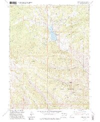
1994 Map of Jimmies Point
USGS Topo · Published 1994About this map
Currant Creek Reservoir sits at the heart of this landscape, its waters contained by a Spillway and monitored by a Gaging Station. The surrounding terrain within the Uinta National Forest is defined by a complex network of canyons and ridges, including the prominent Coyote Ridge and Trout Creek Ridge. This 1994 revision reflects the area's role in both resource management and public land use, featuring the Currant Creek Work Center alongside the Currant Creek Recreation Complex.
Find a feature on this map
37 named features on this map. Tap any name to fly to it.
Don’t see what you’re looking for? This feature index may not catch every label — zoom into the map to look around manually.
Map Details
Editions of this 1994 Jimmies Point Map
This is the sole edition of this map. No revisions or reprints were ever made.
Other maps of this area

1885 · Salt Lake
USGS Topo · 1:250,000

1885 · Uinta
USGS Topo · 1:250,000

1907 · Strawberry Valley
USGS Topo · 1:125,000

1909 · Strawberry Valley
USGS Topo · 1:125,000

1954 · Salt Lake City
USGS Topo · 1:250,000

1958 · Salt Lake City
USGS Topo · 1:250,000

1960 · Salt Lake City
USGS Topo · 1:250,000

1962 · Deep Creek Canyon
USGS Topo · 1:24,000
1962 · Wolf Creek
USGS Topo · 1:24,000

1962 · Raspberry Knoll
USGS Topo · 1:24,000