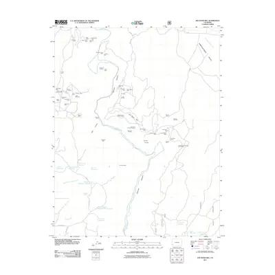
2011 Map of Joe Davis Hill
USGS Topo · Published 2011About this map
Dolores Canyon and the surrounding high country of Dolores County define this landscape, where industrial activity is centered on a dense network of mining claims. The rugged geography is marked by the winding path of the Dolores River, which cuts through the terrain near Joe Davis Hill. Mining operations dominate the northwestern and central portions of the sheet, with family-named or descriptive sites such as the Owensby Mine, Norma Jean Mine, and the Full Moon Group Mine suggesting a history of localized extraction. Water management for this arid region is visible through numerous catchment features, including the Rogers-Dalton Reservoir and Wayne Rogers Reservoir Number Two. Notable landmarks like Spud Patch Camp and Sawmill Spring provide evidence of human occupation and infrastructure in an area primarily shaped by the Disappointment Valley and the resources of the canyon floor.
Find a feature on this map
73 named features on this map. Tap any name to fly to it.
Don’t see what you’re looking for? This feature index may not catch every label — zoom into the map to look around manually.
Map Details
Editions of this 2011 Joe Davis Hill Map
This is the sole edition of this map. No revisions or reprints were ever made.
Other maps of this area

1916 · Paradox Valley
USGS Topo · 1:125,000

1922 · Paradox Valley
USGS Topo · 1:125,000

1948 · Horse Range Mesa
USGS Topo · 1:24,000

1948 · Hamm Canyon
USGS Topo · 1:24,000

1948 · Gypsum Gap
USGS Topo · 1:24,000

1949 · Gypsum Gap
USGS Topo · 1:24,000

1949 · Egnar
USGS Topo · 1:24,000

1949 · Joe Davis Hill
USGS Topo · 1:24,000

1950 · Horse Range Mesa
USGS Topo · 1:24,000
1950 · Hamm Canyon
USGS Topo · 1:24,000