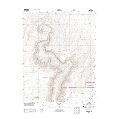
2013 Map of Joe Davis Hill
USGS Topo · Published 2013About this map
The Dolores River carves a deep path through the center of this landscape, defining the dramatic topography of Dolores Canyon as it flows toward the northwest. This 2013 survey of the remote border between San Miguel and Dolores counties reveals a high-desert environment heavily managed for water storage. Numerous small reservoirs, including Wayne Rogers Reservoir Number One, Wayne Rogers Reservoir Number Two, and Rogers-Dalton Reservoir, are scattered across the mesas to support local ranching or wildlife. To the east, the terrain transitions into protected federal lands, where the boundaries of the Uncompahgre National Forest and San Juan National Forest meet. Local landmarks like Joe Davis Hill and Spud Patch Camp provide specific points of reference in a region characterized by canyons and the broad expanse of Disappointment Valley.
Find a feature on this map
42 named features on this map. Tap any name to fly to it.
Don’t see what you’re looking for? This feature index may not catch every label — zoom into the map to look around manually.
Map Details
Editions of this 2013 Joe Davis Hill Map
This is the sole edition of this map. No revisions or reprints were ever made.
Other maps of this area

1916 · Paradox Valley
USGS Topo · 1:125,000

1922 · Paradox Valley
USGS Topo · 1:125,000

1948 · Horse Range Mesa
USGS Topo · 1:24,000

1948 · Hamm Canyon
USGS Topo · 1:24,000

1948 · Gypsum Gap
USGS Topo · 1:24,000

1949 · Gypsum Gap
USGS Topo · 1:24,000

1949 · Egnar
USGS Topo · 1:24,000

1949 · Joe Davis Hill
USGS Topo · 1:24,000

1950 · Horse Range Mesa
USGS Topo · 1:24,000
1950 · Hamm Canyon
USGS Topo · 1:24,000