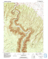
1993 Map of Joe Davis Hill
USGS Topo · Published 1993About this map
The Dolores River carves a deep, winding path through this corner of Southwest Colorado, following the dramatic contours of Dolores Canyon and the surrounding high desert. This 1993 topographic survey documents a landscape defined by its rugged isolation and mineral extraction history, prominently featuring uranium and vanadium mining sites like the Norma Jean No 2 Mine, Sarah Ellen Mine, and Mucho Grande Mine. The presence of Spud Patch Camp (Site) near the canyon rim suggests the transitory nature of work in these remote areas.
Find a feature on this map
31 named features on this map. Tap any name to fly to it.
Don’t see what you’re looking for? This feature index may not catch every label — zoom into the map to look around manually.
Map Details
Editions of this 1993 Joe Davis Hill Map
This is the sole edition of this map. No revisions or reprints were ever made.
Other maps of this area

1916 · Paradox Valley
USGS Topo · 1:125,000

1922 · Paradox Valley
USGS Topo · 1:125,000

1948 · Horse Range Mesa
USGS Topo · 1:24,000

1948 · Hamm Canyon
USGS Topo · 1:24,000

1948 · Gypsum Gap
USGS Topo · 1:24,000

1949 · Gypsum Gap
USGS Topo · 1:24,000

1949 · Egnar
USGS Topo · 1:24,000

1949 · Joe Davis Hill
USGS Topo · 1:24,000

1950 · Horse Range Mesa
USGS Topo · 1:24,000
1950 · Hamm Canyon
USGS Topo · 1:24,000