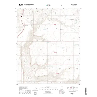
2018 Map of Joes Hill
USGS Topo · Published 2018About this map
Perry Mesa and its high desert plateau define this region of Yavapai County, where deep incisions like Baby Canyon and Lousy Canyon cut through the volcanic landscape. The Aqua Fria River winds along the western edge, serving as a primary drainage for the area. This 2018 survey reveals an environment structured around water management for livestock, indicated by the numerous catchment points such as Pipe Tank, Joes Tank, and Batt Tank scattered across the mesa tops. The southern portion of the map encompasses a section of the Tonto National Forest, where the terrain drops away into the Larry Cr drainage. Significant local routes like Bloody Basin Rd and Badger Springs Rd provide access to this isolated landscape, which remains largely defined by its natural topography and early ranching infrastructure rather than modern development.
Find a feature on this map
36 named features on this map. Tap any name to fly to it.
Don’t see what you’re looking for? This feature index may not catch every label — zoom into the map to look around manually.
Map Details
Editions of this 2018 Joes Hill Map
This is the sole edition of this map. No revisions or reprints were ever made.
Other maps of this area

1887 · Verde
USGS Topo · 1:250,000

1887 · Prescott
USGS Topo · 1:250,000

1892 · Verde
USGS Topo · 1:250,000

1892 · Prescott
USGS Topo · 1:250,000

1903 · Bradshaw Mountains
USGS Topo · 1:125,000

1929 · Turret Peak
USGS Topo · 1:125,000

1933 · Turret Peak
USGS Topo · 1:125,000

1947 · Bumblebee
USGS Topo · 1:62,500

1947 · Mayer
USGS Topo · 1:62,500

1948 · Bumblebee
USGS Topo · 1:63,360