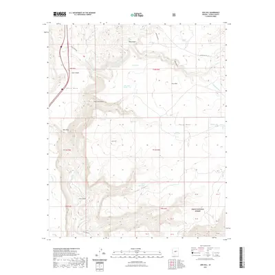
2021 Map of Joes Hill
USGS Topo · Published 2021About this map
Joes Hill stands as a central landmark in this high-desert landscape of central Arizona, where the deeply carved channel of the Aqua Fria River cuts through volcanic plateaus. To the east, the expansive Perry Mesa dominates the horizon, while Black Mesa defines the western edge of the quadrangle. This area is characterized by a network of seasonal drainages and canyons, including the provocatively named Lousy Canyon and Baby Canyon, which feed into the primary river system. The presence of numerous stock ponds and water catchments, such as Perry Mesa Tank and Joes Tank, underscores the importance of water management for ranching in this arid environment. The southeastern portion of the map transitions into the Tonto National Forest, where the topography becomes more complex. Historic transportation routes like Bloody Basin Rd and Badger Springs Rd provide access through this remote territory, tracing the same natural corridors used for generations to traverse the Yavapai backcountry.
Find a feature on this map
46 named features on this map. Tap any name to fly to it.
Don’t see what you’re looking for? This feature index may not catch every label — zoom into the map to look around manually.
Map Details
Editions of this 2021 Joes Hill Map
This is the sole edition of this map. No revisions or reprints were ever made.
Other maps of this area

1887 · Verde
USGS Topo · 1:250,000

1887 · Prescott
USGS Topo · 1:250,000

1892 · Verde
USGS Topo · 1:250,000

1892 · Prescott
USGS Topo · 1:250,000

1903 · Bradshaw Mountains
USGS Topo · 1:125,000

1929 · Turret Peak
USGS Topo · 1:125,000

1933 · Turret Peak
USGS Topo · 1:125,000

1947 · Bumblebee
USGS Topo · 1:62,500

1947 · Mayer
USGS Topo · 1:62,500

1948 · Bumblebee
USGS Topo · 1:63,360