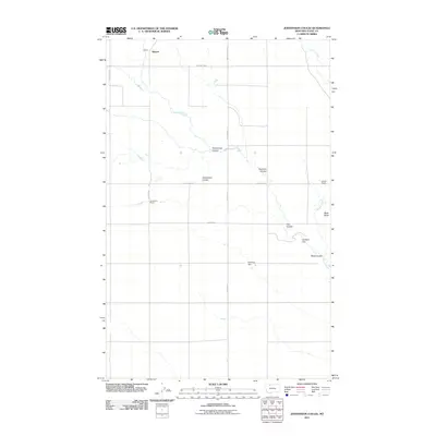
2011 Map of Johannson Coulee
USGS Topo · Published 2011About this map
Kippen and the high plains of Toole County are defined by a network of seasonal drainage channels in this 2011 survey. The landscape is dominated by namesake geographical features like Johannson Coulee and Flat Coulee, which cut through the open terrain toward Willow Creek. The map provides a clear record of local land use and infrastructure, identifying established homesteads such as Johannson Ranch and Elkholt Ranch. Water management is evident through small-scale works including Ucaliptus Dam and Eide Trail Dam, essential for ranching in this arid region. Rising above the coulees, Black Butte serves as a prominent landmark in the eastern portion of the quadrangle. Local transportation is represented by a grid of secondary roads like Oilmont Hwy and Telstad Rd, illustrating the intersection of natural topography and rural development.
Find a feature on this map
18 named features on this map. Tap any name to fly to it.
Don’t see what you’re looking for? This feature index may not catch every label — zoom into the map to look around manually.
Map Details
Editions of this 2011 Johannson Coulee Map
This is the sole edition of this map. No revisions or reprints were ever made.
Other maps of this area

1943 · Antelope Coulee
USGS Topo · 1:62,500

1945 · West Butte
USGS Topo · 1:62,500

1954 · Shelby
USGS Topo · 1:250,000

1958 · Shelby
USGS Topo · 1:250,000

1962 · Cameron Lake
USGS Topo · 1:24,000

1962 · Hawthorne School
USGS Topo · 1:24,000

1962 · Mc Carters Lake
USGS Topo · 1:24,000

1984 · Sweet Grass Hills
USGS Topo · 1:100,000
1986 · Antelope Coulee SW
USGS Topo · 1:24,000
1986 · Antelope Coulee NW
USGS Topo · 1:24,000