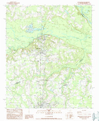
1990 Map of Johnsonville
USGS Topo · Published 1990About this map
The Great Pee Dee River and the Lynches River converge in this Lowcountry landscape, defining the borders of Florence, Marion, and Williamsburg counties. In the early 1990s, the area reflects a transition between traditional river-and-rail settlements like Johnsonville and Hemingway and the industrial activity of Sand & Gravel Pits. The terrain is characterized by a network of slow-moving water bodies such as Muddy Creek and Tie Lake, punctuated by crossroads communities like Ard Crossroads and Crooks Crossroads. This provisional survey preserves the fine-scale details of rural South Carolina, from the secluded Honey Lake to the scattered Cem locations that provide valuable data for local genealogists. The map also records mid-century infrastructure, including a prominent Radio Tower and a local Golf Course, showing how the land was utilized as these historic river towns expanded toward the end of the twentieth century.
Find a feature on this map
20 named features on this map. Tap any name to fly to it.
Don’t see what you’re looking for? This feature index may not catch every label — zoom into the map to look around manually.
Map Details
Editions of this 1990 Johnsonville Map
This is the sole edition of this map. No revisions or reprints were ever made.
Other maps of this area

1943 · Henry
USGS Topo · 1:24,000

1943 · Outland
USGS Topo · 1:24,000

1944 · Outland
USGS Topo · 1:31,680

1946 · Hyman
USGS Topo · 1:62,500

1946 · Johnsonville
USGS Topo · 1:62,500

1946 · Indiantown
USGS Topo · 1:62,500

1949 · Georgetown
USGS Topo · 1:250,000

1967 · Georgetown
USGS Topo · 1:250,000

1974 · Georgetown
USGS Topo · 1:250,000

1986 · Kingstree
USGS Topo · 1:100,000