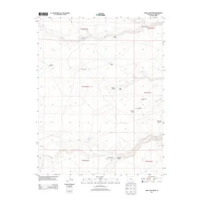
2013 Map of Jones Lake Spring
USGS Topo · Published 2013About this map
Harte Ranch sits within a landscape defined by seasonal water sources and livestock infrastructure in this southern Colorado quadrangle. The terrain is deeply incised by numerous drainages, including Tejana Arroyo and Jones Lake Canyon, which provide a complex topographical profile for researchers of the local environment. Essential for high-plains ranching, several named water points are documented, such as Sanchez Spring, Harte Spring, and Alum Spring.
Find a feature on this map
29 named features on this map. Tap any name to fly to it.
Don’t see what you’re looking for? This feature index may not catch every label — zoom into the map to look around manually.
Map Details
Editions of this 2013 Jones Lake Spring Map
This is the sole edition of this map. No revisions or reprints were ever made.
Other maps of this area

1891 · Apishapa
USGS Topo · 1:125,000

1893 · Apishapa
USGS Topo · 1:125,000

1897 · Apishapa
USGS Topo · 1:125,000

1954 · Trinidad
USGS Topo · 1:250,000

1955 · Trinidad
USGS Topo · 1:250,000

1958 · Trinidad
USGS Topo · 1:250,000

1959 · Trinidad
USGS Topo · 1:250,000
1970 · Myers Canyon
USGS Topo · 1:24,000
1970 · Sanford Hills
USGS Topo · 1:24,000
1971 · South Rattlesnake Butte
USGS Topo · 1:24,000