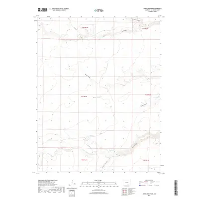
2019 Map of Jones Lake Spring
USGS Topo · Published 2019About this map
Jones Lake Spring and several other water sources anchor this arid landscape of the Colorado high plains in Las Animas County. The terrain is defined by a series of deep drainages including Jones Lake Canyon and Hickok Canyon, which carve through the plateau. These natural features provided critical water and shelter for ranching operations in a region where surface water is scarce. Reliable sources like Sanchez Spring, Harte Spring, and Alum Spring are joined by the Tejana Arroyo, which winds through the southern townships. The sparse road network, featuring Co RD 90 and Co RD 91.9, follows the natural contours of the land, connecting remote ranch sites across the township and range grid system.
Find a feature on this map
22 named features on this map. Tap any name to fly to it.
Don’t see what you’re looking for? This feature index may not catch every label — zoom into the map to look around manually.
Map Details
Editions of this 2019 Jones Lake Spring Map
This is the sole edition of this map. No revisions or reprints were ever made.
Other maps of this area

1891 · Apishapa
USGS Topo · 1:125,000

1893 · Apishapa
USGS Topo · 1:125,000

1897 · Apishapa
USGS Topo · 1:125,000

1954 · Trinidad
USGS Topo · 1:250,000

1955 · Trinidad
USGS Topo · 1:250,000

1958 · Trinidad
USGS Topo · 1:250,000

1959 · Trinidad
USGS Topo · 1:250,000
1970 · Myers Canyon
USGS Topo · 1:24,000
1970 · Sanford Hills
USGS Topo · 1:24,000
1971 · South Rattlesnake Butte
USGS Topo · 1:24,000