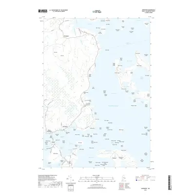
2018 Map of Jonesport
USGS Topo · Published 2018About this map
Moosabec Reach separates the mainland town of Jonesport from the island community of Beals, a maritime landscape defined by its intricate network of coves, bars, and thoroughfares. The coastal character of the area is evident in the cluster of island settlements like Sealand and the northern hamlet of Monsapec. The geography reveals a tradition of shore-based life, with numerous family and place-named features such as French House Island and Parker Head. Local heritage is anchored by sites like Greenwood Cem and Little Pond Beach Greenwood Cem near Pond Beach. The map details a labyrinth of water bodies including Chandler Bay and Englishman Bay, while the Beals Island Bridge provides the primary terrestrial link for the archipelago. This 2018 survey documents the enduring layout of Washington County's fishing villages and granite-rimmed shorelines.
Find a feature on this map
146 named features on this map. Tap any name to fly to it.
Don’t see what you’re looking for? This feature index may not catch every label — zoom into the map to look around manually.
Map Details
Editions of this 2018 Jonesport Map
This is the sole edition of this map. No revisions or reprints were ever made.
Other maps of this area

1918 · Machias
USGS Topo · 1:62,500

1921 · Great Wass Island
USGS Topo · 1:62,500

1921 · Columbia Falls
USGS Topo · 1:62,500

1921 · Columbia Falls
USGS Topo · 1:62,500

1941 · Columbia Falls
USGS Topo · 1:62,500

1941 · Machias
USGS Topo · 1:62,500

1942 · Columbia Falls
USGS Topo · 1:62,500

1948 · Jonesport
USGS Topo · 1:24,000
1948 · Columbia Falls
USGS Topo · 1:24,000

1948 · Roque Bluffs
USGS Topo · 1:24,000