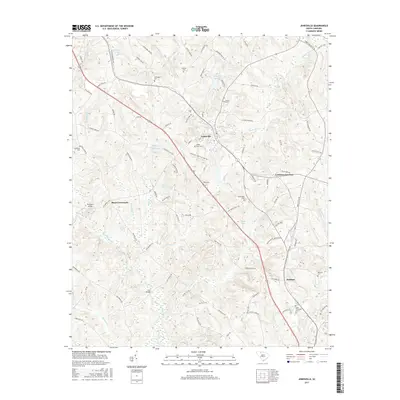
2017 Map of Jonesville
USGS Topo · Published 2017About this map
The town of Jonesville serves as the focal point of this Union County landscape, where the Norfolk Southern railroad line cuts through the Piedmont terrain. This 2017 survey details a region defined by a high concentration of family and community burial grounds, including the Weber-Haile Cem, Gilead Cem, and Mitchell Cem, offering significant value for genealogical research. The geography is shaped by the winding paths of Fairforest Creek and Sandy Run Cr, which feed into various local impoundments like Gallmans Pond and Jonesville Town Pond.
Find a feature on this map
102 named features on this map. Tap any name to fly to it.
Don’t see what you’re looking for? This feature index may not catch every label — zoom into the map to look around manually.
Map Details
Editions of this 2017 Jonesville Map
This is the sole edition of this map. No revisions or reprints were ever made.
Other maps of this area

1941 · Spartanburg
USGS Topo · 1:250,000

1947 · Spartanburg
USGS Topo · 1:62,500

1949 · Spartanburg
USGS Topo · 1:62,500

1953 · Spartanburg
USGS Topo · 1:250,000

1960 · Spartanburg
USGS Topo · 1:250,000

1963 · Spartanburg
USGS Topo · 1:250,000

1964 · Spartanburg
USGS Topo · 1:250,000
1968 · Wilkinsville
USGS Topo · 1:24,000

1969 · Cross Anchor
USGS Topo · 1:24,000
1969 · Pacolet Mills
USGS Topo · 1:24,000