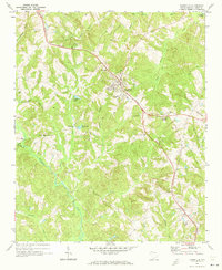
1969 Map of Jonesville
USGS Topo · Published 1973About this map
Jonesville serves as the primary hub of activity in this part of Union County, centered on the Southern railroad line as it was documented in the late 1960s. The landscape is defined by a dense network of tributaries including Fairforest Creek, Cunningham Creek, and Sandy Run which flow toward the Pacolet River in the northeast. Rural life is anchored by community landmarks such as Littlejohn Com and numerous churches like Fosters Chapel and Gilead Ch.
Find a feature on this map
37 named features on this map. Tap any name to fly to it.
Don’t see what you’re looking for? This feature index may not catch every label — zoom into the map to look around manually.
Map Details
Editions of this 1969 Jonesville Map
This is the sole edition of this map. No revisions or reprints were ever made.
Other maps of this area

1941 · Spartanburg
USGS Topo · 1:250,000

1947 · Spartanburg
USGS Topo · 1:62,500

1949 · Spartanburg
USGS Topo · 1:62,500

1953 · Spartanburg
USGS Topo · 1:250,000

1960 · Spartanburg
USGS Topo · 1:250,000

1963 · Spartanburg
USGS Topo · 1:250,000

1964 · Spartanburg
USGS Topo · 1:250,000
1968 · Wilkinsville
USGS Topo · 1:24,000

1969 · Cross Anchor
USGS Topo · 1:24,000
1969 · Pacolet Mills
USGS Topo · 1:24,000