1986 Map of Joseph City
USGS Topo · Published 1986About this map
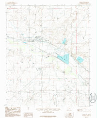
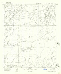
Joseph City serves as the central hub of this Navajo County landscape, where the Atchison Topeka and Santa Fe railroad and the Little Colorado River run parallel through the high desert. The map captures a complex water management system vital to the arid region, including the Joseph City Ditch, a protective levee, and an aqueduct feeding the large basin of Cholla Lake. Evidence of the area's industrial infrastructure is prominent near the water, with a dedicated power plant and substation located just east of town.
Find a feature on this map
27 named features on this map. Tap any name to fly to it.
Don’t see what you’re looking for? This feature index may not catch every label — zoom into the map to look around manually.
Map Details
Editions of this 1986 Joseph City Map
This is the sole edition of this map. No revisions or reprints were ever made.
Other maps of this area

1883 · Tusayan
USGS Topo · 1:250,000

1886 · Tusayan
USGS Topo · 1:250,000

1886 · Holbrook
USGS Topo · 1:250,000

1893 · Holbrook
USGS Topo · 1:250,000

1947 · Flagstaff
USGS Topo · 1:250,000

1954 · Flagstaff
USGS Topo · 1:250,000

1954 · Holbrook
USGS Topo · 1:250,000
1955 · Mal Pais Springs 3 SW
USGS Topo · 1:24,000
1955 · St. Joseph 2 SE
USGS Topo · 1:24,000
1955 · St. Joseph 2 NW
USGS Topo · 1:24,000