1955 Map of St. Joseph 2 SE
USGS Topo · Published 1957About this map
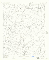
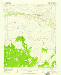
Ranching infrastructure and high-desert terrain define this mid-century survey of the Arizona interior. The landscape is marked by a network of essential water catchments and stock improvements, indicating a region dedicated to livestock grazing. Named points of interest include Saunders Tank and Rattlesnake Tank, while several unnamed Windmill sites are scattered along unpaved tracks and section lines. The topography is anchored by two prominent survey markers, Gunner VABM 5293 in the northwest and Wildcat VABM 5725 in the southwest, providing a sense of the undulating elevation changes typical of Navajo County. Drainage patterns are highlighted by the presence of Porter Draw, which winds through the southeastern portion of the quadrangle. These features collectively reflect the practical requirements of range management in the 1950s, showing a territory where water sources were the primary landmarks for navigation and land use.
Find a feature on this map
9 named features on this map. Tap any name to fly to it.
Don’t see what you’re looking for? This feature index may not catch every label — zoom into the map to look around manually.
Map Details
Editions of this 1955 St. Joseph 2 SE Map
This is the sole edition of this map. No revisions or reprints were ever made.
Other maps of this area

1886 · Holbrook
USGS Topo · 1:250,000

1893 · Holbrook
USGS Topo · 1:250,000

1954 · Holbrook
USGS Topo · 1:250,000
1955 · St. Joseph 2 NW
USGS Topo · 1:24,000
1955 · St. Joseph 1 NW
USGS Topo · 1:24,000
1955 · St. Joseph 2 NE
USGS Topo · 1:24,000
1955 · Joseph City
USGS Topo · 1:62,500
1955 · Holbrook
USGS Topo · 1:62,500

1957 · Holbrook
USGS Topo · 1:250,000

1958 · Holbrook
USGS Topo · 1:250,000