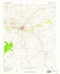
1955 Map of Holbrook
USGS Topo · Published 1959About this map
Holbrook serves as the central hub of this mid-century desert landscape, where the Atchison Topeka and Santa Fe railroad parallels the Little Colorado River. The map captures a moment of local institutional growth, featuring the Yalta Indian School and Navajo Mission School on the outskirts of the town center. To the southeast, the prominent volcanic landmark of Woodruff Butte stands near the small settlement of Woodruff and its namesake Woodruff Lake. The infrastructure of the 1950s is evident in the presence of the Holbrook Airport and a prominent Drive-in Theater, alongside ranching landmarks like Jeffers Ranch and the Flake Windmill. Numerous drainage systems, including Apache Wash and Fivemile Wash, illustrate the complex hydrology of the high desert plateau surrounding the rail corridor.
Find a feature on this map
32 named features on this map. Tap any name to fly to it.
Don’t see what you’re looking for? This feature index may not catch every label — zoom into the map to look around manually.
Map Details
Editions of this 1955 Holbrook Map
2 editions found
Other maps of this area

1883 · Tusayan
USGS Topo · 1:250,000

1886 · St Johns
USGS Topo · 1:250,000

1886 · Tusayan
USGS Topo · 1:250,000

1886 · Fort Defiance
USGS Topo · 1:250,000

1886 · Holbrook
USGS Topo · 1:250,000

1892 · Fort Defiance
USGS Topo · 1:250,000

1892 · St Johns
USGS Topo · 1:250,000

1893 · Holbrook
USGS Topo · 1:250,000

1912 · Petrified Forest
USGS Topo · 1:62,500

1947 · Flagstaff
USGS Topo · 1:250,000