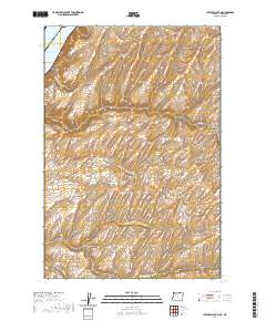
2020 Map of Juniper Canyon
USGS Topo · Published 2020About this map
Lake Wallula defines the northwest corner of this landscape, where the state boundary separates Benton Co Washington from Umatilla Co Oregon. The terrain is characterized by a series of significant drainage systems, most notably the winding paths of Juniper Canyon and its tributaries, the North Fork Juniper Canyon and South Fork Juniper Canyon. These deep incisions into the plateau reveal a complex network of ridges and draws that have long dictated the movement of people and livestock through the region.
Find a feature on this map
13 named features on this map. Tap any name to fly to it.
Don’t see what you’re looking for? This feature index may not catch every label — zoom into the map to look around manually.
Map Details
Editions of this 2020 Juniper Canyon Map
This is the sole edition of this map. No revisions or reprints were ever made.
Other maps of this area

1908 · Umatilla
USGS Topo · 1:125,000

1915 · Wallulah
USGS Topo · 1:96,000

1917 · Pasco
USGS Topo · 1:125,000

1918 · Wallula
USGS Topo · 1:125,000

1935 · Pendleton
USGS Topo · 1:125,000

1953 · Pendleton
USGS Topo · 1:250,000

1953 · Walla Walla
USGS Topo · 1:250,000

1956 · Pendleton
USGS Topo · 1:250,000

1958 · Walla Walla
USGS Topo · 1:250,000

1962 · Juniper
USGS Topo · 1:24,000