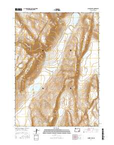
2017 Map of Juniper Lake
USGS Topo · Published 2017About this map
Steens Mtn dominates this Harney County landscape, where the high desert terrain of southeastern Oregon is punctuated by a series of alkaline basins and ephemeral water sources. The map reveals a complex hydrography including the curiously named Ten Cent Lake and Fifteen Cent Lake, alongside larger bodies like Juniper Lake and Puhi-Pane Na-De Lake. These seasonal lakes and springs, such as Neal Spring and Negro Springs, have long served as vital landmarks in an arid environment. Transportation through this remote section is defined by long, straight stretches like the Fields-Denio Rd and the steep ascent of the Juniper Grade. These routes trace the edge of the mountains, connecting the valley floors with the high ridges, while landmarks like Heath Lake and Pollock Reservoir indicate the ongoing human management of scarce water resources for ranching and livestock.
Find a feature on this map
21 named features on this map. Tap any name to fly to it.
Don’t see what you’re looking for? This feature index may not catch every label — zoom into the map to look around manually.
Map Details
Editions of this 2017 Juniper Lake Map
This is the sole edition of this map. No revisions or reprints were ever made.
Other maps of this area

1955 · Burns
USGS Topo · 1:250,000

1955 · Adel
USGS Topo · 1:250,000

1957 · Adel
USGS Topo · 1:250,000

1958 · Burns
USGS Topo · 1:250,000

1958 · Adel
USGS Topo · 1:250,000

1959 · Burns
USGS Topo · 1:250,000

1962 · Adel
USGS Topo · 1:250,000

1974 · Anderson Mtn
USGS Topo · 1:62,500
1974 · Folly Farm
USGS Topo · 1:24,000
1974 · Folly Farm
USGS Topo · 1:62,500