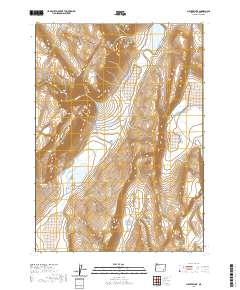
2020 Map of Juniper Lake
USGS Topo · Published 2020About this map
Steens Mtn dominates the western topography of this Harney County quadrangle, where the high desert landscape is defined by its scattered water sources and rugged relief. This survey records a system of drainages and seasonal basins, notably Juniper Lake and Ten-Cent Lake, which serve as critical landmarks in an arid environment. The presence of named water features like Neal Spring and Negro Springs indicates the vital importance of reliable water to the region's history of ranching and transit. These springs, alongside Heath Cr and Squaw Cr, dictate the movement and settlement patterns across the sagebrush-covered terrain. Human infrastructure is primarily represented by the Fields-Denio Rd and E Steens Rd, connecting the remote southern Oregon basins. To the southeast, the Pollock Reservoir further illustrates the management of water resources in this high-altitude corner of the state.
Find a feature on this map
17 named features on this map. Tap any name to fly to it.
Don’t see what you’re looking for? This feature index may not catch every label — zoom into the map to look around manually.
Map Details
Editions of this 2020 Juniper Lake Map
This is the sole edition of this map. No revisions or reprints were ever made.
Other maps of this area

1955 · Burns
USGS Topo · 1:250,000

1955 · Adel
USGS Topo · 1:250,000

1957 · Adel
USGS Topo · 1:250,000

1958 · Burns
USGS Topo · 1:250,000

1958 · Adel
USGS Topo · 1:250,000

1959 · Burns
USGS Topo · 1:250,000

1962 · Adel
USGS Topo · 1:250,000

1974 · Anderson Mtn
USGS Topo · 1:62,500
1974 · Folly Farm
USGS Topo · 1:24,000
1974 · Folly Farm
USGS Topo · 1:62,500