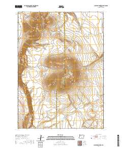
2020 Map of Juniper Mountain
USGS Topo · Published 2020About this map
Juniper Mtn rises as the central landmark of this high-desert landscape on the border of Lake and Harney Counties. Surveyed in 2020, the area shows a distinct pattern of land management through its network of forest and county roads, such as Co Rd 6110 and Big Juniper Rd. The survival of livestock and wildlife in this arid terrain is evidenced by the strategic placement of water sources like Sheep Reservoir, Grays Reservoir, and the descriptive Browns Horse Corral Waterhole. To the north, Grays Butte overlooks Rehart Canyon, while the southern reaches are marked by Badger Draw and its associated reservoir. This modern topographic record captures the intersection of natural volcanic landforms and the essential infrastructure of rural Oregon ranching and forestry.
Find a feature on this map
24 named features on this map. Tap any name to fly to it.
Don’t see what you’re looking for? This feature index may not catch every label — zoom into the map to look around manually.
Map Details
Editions of this 2020 Juniper Mountain Map
This is the sole edition of this map. No revisions or reprints were ever made.
Other maps of this area

1955 · Crescent
USGS Topo · 1:250,000

1955 · Klamath Falls
USGS Topo · 1:250,000

1955 · Burns
USGS Topo · 1:250,000

1955 · Adel
USGS Topo · 1:250,000

1957 · Adel
USGS Topo · 1:250,000

1957 · Crescent
USGS Topo · 1:250,000

1958 · Crescent
USGS Topo · 1:250,000

1958 · Klamath Falls
USGS Topo · 1:250,000

1958 · Burns
USGS Topo · 1:250,000

1958 · Adel
USGS Topo · 1:250,000