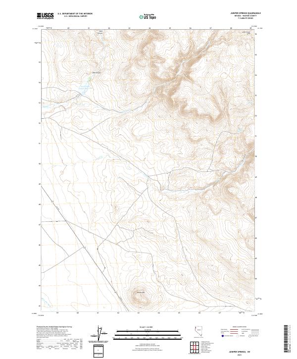
2021 Map of Juniper Springs
USGS Topo · Published 2021About this map
Wall Canyon dominates this high-desert landscape in northern Washoe County, where the storage of water remains central to the geography. The Lower Wall Canyon Reservoir serves as a critical hydrologic landmark in a terrain defined by seasonal drainages like Wall Cr and Cherry Cr. This 2021 survey details a region characterized by isolated water sources such as Juniper Springs and Cherry Springs, which have long been vital for range management and wildlife. The road network is sparse, centered on S R 447 and the unpaved Lost Creek Rd, while the topography rises toward Round Mtn and the Lost Creek Hills. The map clearly delineates the Public Land Survey System grids, showing the intersection of townships T37N and T36N across ranges R19E and R20E.
Find a feature on this map
16 named features on this map. Tap any name to fly to it.
Don’t see what you’re looking for? This feature index may not catch every label — zoom into the map to look around manually.
Map Details
Editions of this 2021 Juniper Springs Map
This is the sole edition of this map. No revisions or reprints were ever made.
Other maps of this area

1886 · Granite Range
USGS Topo · 1:250,000

1889 · Long Valley
USGS Topo · 1:250,000

1894 · Granite Range
USGS Topo · 1:250,000

1954 · Vya
USGS Topo · 1:250,000

1955 · Lovelock
USGS Topo · 1:250,000

1958 · Vya
USGS Topo · 1:250,000

1959 · Lovelock
USGS Topo · 1:250,000

1962 · Vya
USGS Topo · 1:250,000
1979 · Wall Canyon Reservoir
USGS Topo · 1:24,000
1979 · Duck Lake
USGS Topo · 1:24,000