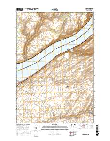
2017 Map of Juniper
USGS Topo · Published 2017About this map
The Columbia River serves as the defining border between Washington and Oregon, carving through the Columbia Plateau as it flows toward the Pacific. This 2017 survey shows the expansive waters of Lake Wallula, a reservoir backed by downstream dams, which has transformed the riverine landscape into a broad waterway dotted by features such as Van Skinner Island. On the northern bank in Benton County, Washington, the terrain is marked by steep drainage systems like Spaw Canyon and Juniper Canyon, leading toward the small settlement of Juniper. South of the state line in Umatilla County, Oregon, the topography flattens somewhat before dropping into Cold Springs Canyon and its associated South Fork Cold Springs Canyon. Rural infrastructure is limited to secondary routes like Co Rd 892 and Wallula Rd, reflecting the area's sparse development and reliance on the river as a geographic anchor.
Find a feature on this map
20 named features on this map. Tap any name to fly to it.
Don’t see what you’re looking for? This feature index may not catch every label — zoom into the map to look around manually.
Map Details
Editions of this 2017 Juniper Map
This is the sole edition of this map. No revisions or reprints were ever made.
Other maps of this area

1908 · Umatilla
USGS Topo · 1:125,000

1915 · Wallulah
USGS Topo · 1:96,000

1917 · Pasco
USGS Topo · 1:125,000

1918 · Wallula
USGS Topo · 1:125,000

1935 · Pendleton
USGS Topo · 1:125,000

1953 · Pendleton
USGS Topo · 1:250,000

1953 · Walla Walla
USGS Topo · 1:250,000

1956 · Pendleton
USGS Topo · 1:250,000

1958 · Walla Walla
USGS Topo · 1:250,000

1962 · Hat Rock
USGS Topo · 1:24,000