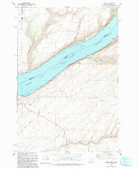
1993 Map of Juniper
USGS Topo · Published 1993About this map
Lake Wallula dominates this borderlands topography, where the Columbia River forms the divide between Benton County, Washington, and Umatilla County, Oregon. This early 1990s survey illustrates a landscape of deeply incised drainages, including Swaler Canyon, Spaw Canyon, and the extensive Cold Springs Canyon in the south. The settlement at Juniper sits near the river's edge, while the inland areas are marked by infrastructure such as a Landing Strip, a Pipeline, and various substations. Local travel and access are defined by a network of unimproved roads and four-wheel-drive trails, alongside named routes like Kosmos Road and East Walls Road. The presence of a Sand Station Recreation Area and various gravel pits suggests a mix of public use and local resource extraction in this arid riverine environment.
Find a feature on this map
19 named features on this map. Tap any name to fly to it.
Don’t see what you’re looking for? This feature index may not catch every label — zoom into the map to look around manually.
Map Details
Editions of this 1993 Juniper Map
This is the sole edition of this map. No revisions or reprints were ever made.
Other maps of this area

1908 · Umatilla
USGS Topo · 1:125,000

1915 · Wallulah
USGS Topo · 1:96,000

1917 · Pasco
USGS Topo · 1:125,000

1918 · Wallula
USGS Topo · 1:125,000

1935 · Pendleton
USGS Topo · 1:125,000

1953 · Pendleton
USGS Topo · 1:250,000

1953 · Walla Walla
USGS Topo · 1:250,000

1956 · Pendleton
USGS Topo · 1:250,000

1958 · Walla Walla
USGS Topo · 1:250,000

1962 · Hat Rock
USGS Topo · 1:24,000