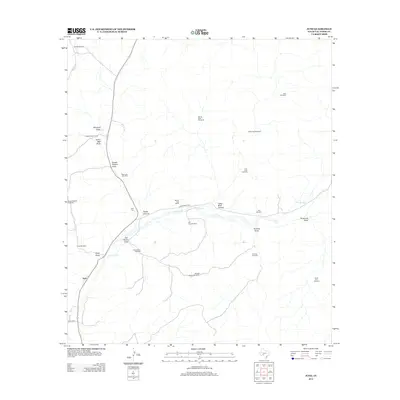
2012 Map of Juno
USGS Topo · Published 2012About this map
The Devils River winds through this arid stretch of Val Verde County, carving a path through deep limestone topography. This remote ranching landscape is defined by its water-management infrastructure, featuring a dense network of isolated windmills such as Windy Point Windmill, Bull Windmill, and Middle Pasture Windmill that sustain the local livestock operations. Human presence centers on established holdings like Beaver Lake Ranch and Pecos Canyon Ranch, while transportation is facilitated by Ranch Road 189. Cultural history is anchored at the Juno Cem, a key landmark for local genealogy. The terrain is deeply incised by numerous seasonal drainage systems, including Pecos Canyon, Cedar Bluff Canyon, and several named draws like Sulfur Well Draw and Threemile Draw, reflecting the erosive power of occasional desert rain on the plateau.
Find a feature on this map
29 named features on this map. Tap any name to fly to it.
Don’t see what you’re looking for? This feature index may not catch every label — zoom into the map to look around manually.
Map Details
Editions of this 2012 Juno Map
This is the sole edition of this map. No revisions or reprints were ever made.
Other maps of this area

1954 · Sonora
USGS Topo · 1:250,000

1958 · Sonora
USGS Topo · 1:250,000

1967 · Flat Rock Draw SW
USGS Topo · 1:24,000

1970 · Juno
USGS Topo · 1:24,000

1970 · Indian Draw
USGS Topo · 1:24,000

1970 · Sycamore Canyon
USGS Topo · 1:24,000

1970 · Bee Canyon
USGS Topo · 1:24,000

1970 · Brushy Draw
USGS Topo · 1:24,000

1970 · Deaton Draw
USGS Topo · 1:24,000

1973 · White Draw NW
USGS Topo · 1:24,000