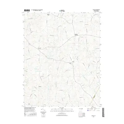
2016 Map of Justice
USGS Topo · Published 2016About this map
Stallings Crossroads and Justice anchor this rural landscape in the northeastern Piedmont, where the drainage of the Tar River and Sycamore Cr carves the terrain into a network of small ridges and creek bottoms. The 2016 survey illustrates a community deeply rooted in its geography, with historic family-named roads like Ronald Tharrington Rd, Walter Collins Rd, and Mort Harris Rd connecting the scattered settlements of Mapleville, Hickory Rock, and Margaret. The presence of Farrell Bridge over the river and the impoundments at Harris Pond Number Two and Harris Pond Number Three reveal the local water management essential for this agricultural region. The eastern boundary is defined by the Franklin Co and Nash Co line, crossing through the watershed of Little Peachtree Cr. This map provides a detailed view of modern rural North Carolina, preserving the locations of community landmarks like Stallings Memorial Park.
Find a feature on this map
73 named features on this map. Tap any name to fly to it.
Don’t see what you’re looking for? This feature index may not catch every label — zoom into the map to look around manually.
Map Details
Editions of this 2016 Justice Map
This is the sole edition of this map. No revisions or reprints were ever made.
Other maps of this area

1902 · Spring Hope
USGS Topo · 1:62,500

1904 · Springhope
USGS Topo · 1:62,500

1953 · Raleigh
USGS Topo · 1:250,000

1953 · Greensboro
USGS Topo · 1:250,000

1954 · Greensboro
USGS Topo · 1:250,000

1954 · Raleigh
USGS Topo · 1:250,000

1962 · Greensboro
USGS Topo · 1:250,000

1966 · Greensboro
USGS Topo · 1:250,000

1968 · Bunn West
USGS Topo · 1:24,000
1978 · Bunn East
USGS Topo · 1:24,000