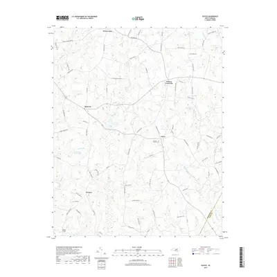
2019 Map of Justice
USGS Topo · Published 2019About this map
Justice and Stallings Crossroads serve as central nodes for this rural pocket of North Carolina where the Franklin Co and Nash Co border is defined by local waterways. The landscape is heavily dissected by the drainage systems of Big Peachtree Cr and Cypress Cr, creating a network of ridges and small valleys occupied by small settlements such as Mapleville, Margaret, and Hickory Rock. The road network often bears the names of local families, including Walter Collins Rd and Earlie Collins Rd, suggesting long-standing ancestral ties to the land. This survey captures the area in the late 2010s, showing the intersection of traditional agricultural routes with modern waypoints like Stallings Memorial Park. Features like Farrell Bridge and Harris Pond Number Two highlight how the local community has historically managed and crossed the numerous streams flowing through the region.
Find a feature on this map
75 named features on this map. Tap any name to fly to it.
Don’t see what you’re looking for? This feature index may not catch every label — zoom into the map to look around manually.
Map Details
Editions of this 2019 Justice Map
This is the sole edition of this map. No revisions or reprints were ever made.
Other maps of this area

1902 · Spring Hope
USGS Topo · 1:62,500

1904 · Springhope
USGS Topo · 1:62,500

1953 · Raleigh
USGS Topo · 1:250,000

1953 · Greensboro
USGS Topo · 1:250,000

1954 · Greensboro
USGS Topo · 1:250,000

1954 · Raleigh
USGS Topo · 1:250,000

1962 · Greensboro
USGS Topo · 1:250,000

1966 · Greensboro
USGS Topo · 1:250,000

1968 · Bunn West
USGS Topo · 1:24,000
1978 · Bunn East
USGS Topo · 1:24,000