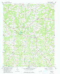
1979 Map of Justice
USGS Topo · Published 1979About this map
Justice and Mapleville anchor this rural landscape in the eastern Piedmont during the late 1970s, where small agricultural communities are linked by a network of local roads crossing the Tar River and its numerous tributaries. The map details a social geography defined by numerous country churches, including Duke Memorial Ch and Walnut Grove Ch, along with community hubs like Bunn High Sch and Stallings Memorial Park. The drainage patterns of Cypress Creek and Big Peachtree Creek show the undulating terrain of the Franklin Co and Nash Co border region. A mix of small settlements such as Hickory Rock and Harrisville reveal a persistent pattern of rural habitation, while landmarks like the Radio Tower near Margaret signal the era's modern infrastructure. For genealogists and local historians, the numerous scattered Cems and small family-named water bodies like Jacksons Pond offer specific points of reference for land ownership and community heritage.
Find a feature on this map
30 named features on this map. Tap any name to fly to it.
Don’t see what you’re looking for? This feature index may not catch every label — zoom into the map to look around manually.
Map Details
Editions of this 1979 Justice Map
This is the sole edition of this map. No revisions or reprints were ever made.
Other maps of this area

1902 · Spring Hope
USGS Topo · 1:62,500

1904 · Springhope
USGS Topo · 1:62,500

1953 · Raleigh
USGS Topo · 1:250,000

1953 · Greensboro
USGS Topo · 1:250,000

1954 · Greensboro
USGS Topo · 1:250,000

1954 · Raleigh
USGS Topo · 1:250,000

1962 · Greensboro
USGS Topo · 1:250,000

1966 · Greensboro
USGS Topo · 1:250,000

1968 · Bunn West
USGS Topo · 1:24,000
1978 · Bunn East
USGS Topo · 1:24,000