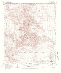
1958 Map of Kaka
USGS Topo · Published 1967About this map
Kaka and the surrounding desert landscape of the Papago Indian Reservation define this late-1950s survey of southern Arizona. The terrain is dominated by the Sand Tank Mountains and Sauceda Mountains, with the prominent landmark Squaw Tit rising near the center of the sheet. The northern portion of the quadrangle is occupied by the Luke Air Force Range, signaling the military presence in the region during the Cold War era.
Find a feature on this map
25 named features on this map. Tap any name to fly to it.
Don’t see what you’re looking for? This feature index may not catch every label — zoom into the map to look around manually.
Map Details
Editions of this 1958 Kaka Map
2 editions found
Other maps of this area

1941 · Vekol Mountains
USGS Topo · 1:62,500

1942 · Vekol Mountains
USGS Topo · 1:62,500

1946 · Antelope Peak
USGS Topo · 1:62,500

1948 · Antelope Peak
USGS Topo · 1:62,500

1951 · Estrella
USGS Topo · 1:62,500

1951 · Gila Bend
USGS Topo · 1:62,500

1953 · Ajo
USGS Topo · 1:250,000

1957 · Ajo
USGS Topo · 1:250,000

1958 · Ajo
USGS Topo · 1:250,000

1958 · Kaka
USGS Topo · 1:62,500