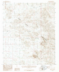
1986 Map of Kaka NW
USGS Topo · Published 1986About this map
Luke Air Force Range dominates this mid-1980s topographic landscape, where the shifting sands of the Sonoran Desert meet the sharp topography of the Mountains. This region is defined by its arid drainage networks, primarily the broad Sand Tank Wash and Quijotoa Wash, which reveal the hydrology of the Maricopa backcountry before modern development patterns. Notable landmarks such as Dragons Tooth and the distinctive Squaw Tit peak serve as primary orientation points for those studying the rugged terrain of the Arizona interior. The inclusion of Burro Spring marks a rare and critical water source in a landscape otherwise characterized by seasonal washes and extreme exposure. This survey provides a precise look at the military boundary and natural landforms during a period when these ranges remained largely isolated from the growing metropolitan footprints to the north.
Find a feature on this map
10 named features on this map. Tap any name to fly to it.
Don’t see what you’re looking for? This feature index may not catch every label — zoom into the map to look around manually.
Map Details
Editions of this 1986 Kaka NW Map
This is the sole edition of this map. No revisions or reprints were ever made.
Other maps of this area

1951 · Estrella
USGS Topo · 1:62,500

1951 · Gila Bend
USGS Topo · 1:62,500

1953 · Ajo
USGS Topo · 1:250,000

1957 · Ajo
USGS Topo · 1:250,000

1958 · Ajo
USGS Topo · 1:250,000

1958 · Kaka
USGS Topo · 1:62,500

1958 · Hat Mountain
USGS Topo · 1:62,500

1962 · Ajo
USGS Topo · 1:250,000

1963 · Ajo
USGS Topo · 1:250,000

1967 · Ajo
USGS Topo · 1:250,000